GoSmarter, GoActive Walking and Cycling Maps
20 February 2024
Initiated by Transport North East (TNE) on behalf of the North East Joint Transport Committee in 2021, the GoSmarter, GoActive campaign was introduced to promote pedestrian, cycling, and wheeling journeys throughout the North East in the post-lockdown era. As an integral component of this initiative, TNE sought to develop a comprehensive series of maps encompassing the seven counties participating in the project, exploring innovative approaches to facilitate online accessibility.
Following a rigorous competitive tender process, Pindar Creative secured the contract, mandated to complete the project within a demanding four-month timeline. The project involved coordination with various stakeholders from each local authority, facilitated through the utilisation of project management software, complemented by regular weekly meetings with the local authority teams. Collaboration extended to standardising cycle infrastructure data provided by each authority, ensuring uniform representation across the region on the maps.
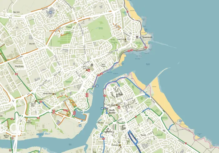
The resulting maps were created as two seamless bases: one at a scale of 1:70,000 covering the entire region, and another at 1:20,000 encompassing five local authorities in their entirety, as well as urban segments of County Durham and Northumberland.
Two online mapping options were proposed. The first option featured a cost-effective series of interactive PDFs, incorporating navigation tabs along the map edges to facilitate seamless transitions between regions. The second option presented an online mapping solution utilising the two seamless bases, offering various zoom levels and interactive hotspots. Users can click on hotspots along National Cycle Network (NCN) routes to access relevant pages on the Sustrans website, or obtain information about bike parking availability and live departure data for Metro or Rail stations.
TNE opted for both options, seamlessly accessible through their microsite. From its homepage, the interactive map provides three different pathways for accessing the mapping - through an overview map, a 'View Map' button, or a search facility, thereby enhancing user accessibility.
The platform offers additional features such as zooming capabilities, layer toggling, location identification, a key and print screen options. A micro-map represents one of three navigational methods available to users.
Furthermore, a 'Useful Links' page directs users to relevant resources, including TNE, Nexus (featuring their journey planner), Living Streets, local bus operators, National Rail Enquiries, and Newcastle Airport, augmenting the platform's utility.